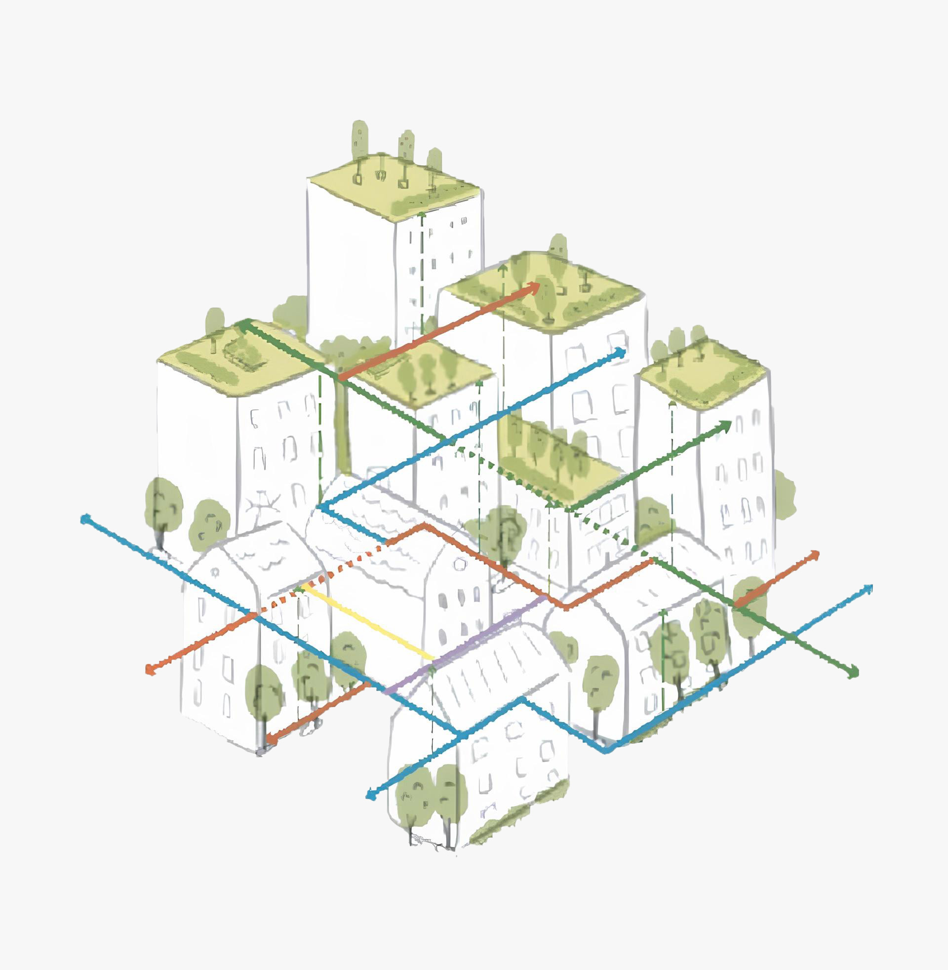
Residents of the connected city leverage from permeable and efficient street network with walkable and cyclable distances to close destinations while having access to multi-modal transport systems to connect with the opportunities of the wider city. Streets in the connected city function as public spaces and cornerstones for Transit Oriented Development and give priority to people and transit over cars. The urban environment of the connected city considers streets as vibrant, safe and attractive open public spaces accessible for all, integrates blue and green networks, support the functionality of the ecosystem, and connecting people with nature.
The Connected City relates to the New Urban Agenda transformative commitments: 34, 36, 37, 39, 54, 62, 67

To ensure an adequate level of the street network that also attracts pedestrians and cyclists, the amount of land needed for roads, and open public spaces has to be determined. As a preliminary reference it is recommended that at least 30 per cent of land is allocated for roads and parking and dedicated non-motorised transit paths, and at least 15-20 per cent is allocated for open public space in high density mixed-use urban areas.

2.1.1 Road Hierarchy
Road networks should support a wide choice of routes based on user heirarchies that prioritises non-motorised transport and pedestrians. It is important that the routes for walking, cycling and public transport are clearly defined. The overall hierarchy must give priority to sustainable modes of transportation (“green hierarchy”) and include arterial routes and local streets based on traffic speed differences. Combining walkability and public transport catchment, the suggested distance between two arterial routes may be between 800 to 1000 m as a reference. Street features should vary according to specific network requirements of each type and functionality of the street.

2.1.2 Street Density
To ensure balance between the street and other land uses, the street network should encompass at least 18 km of street length per square kilometer. The indicator is given as a reference and city management and urban planners could “adjust” the design pattern of the street network, using the street density level that is assessed locally.

2.1.3 Permeable Street Network
An efficient and permeable street network that provides convenient movement should ideally be linked with minimum physical barriers to provide a continuity of pedestrian movement. An efficient and permeable street network might be measured by density of the road intersections. A reference indicator of 80-100 street intersections per km2 might be taken as a preliminary benchmark for the network assessment.
The street permeability (represented by the level of road intersections) may be characterized by different types of street patterns. While designing a neighborhood, an assessment of the vernacular grid might be useful to analyse its climate adaptability and elements that enhance local identity.
2.1.4 Walking Paths and Cycle Connectivity
Pathway and cycling networks should form an unobstructed network and connect to the overall arterial transport system to avoid car-centred streets, and ensuring the possibility to walk and cycle longer distances. A highly interconnected path network provides a choice of walking and cycling routes that lead to other destinations within the city or/and a region. Enforcement processes can be used to support the non-motorised transport network in it’s early phases.
Apart from increasing the level of physical activities and promoting better health, cycling and walking infrastructure might significantly support tourist activities, increase the focus on the environment, etc. While promoting a cycling network, it might be useful to assess the broader contexts to discover the possibility of linking to the broader cycling network.
Residents should have a wide choice of transport modes that are available and accessible, such as cycling, taking public transport / e-transport, driving. Therefore, the street network should provide a variety of ways/options that are safe, affordable and accessible, such as cycling paths, sidewalks, trails, public transport, etc., to key urban services that are universally accessible, to provide ‘last mile’ connectivity.
2.2.1 Convenient Public Transport
Residents should have easy access and a maximum of a 500m walking distance to public transportation considering catchment areas for different transportation forms. Public transport stops should be designed according to contextual needs (provide shade, sitting area, etc) and comply with the standards of universal design.
While designing a public transport stop, it might be useful to analyse the intensity of public transportation, how local communities use stops and assess gender related issues. The outcome of the analysis might help in proposing the most appropriate design for the local needs (e.g. larger shadings that correspond the length of the bus to ensure everyone is protected from sun while boarding the bus, place for street vendors, lighting for night-time use etc.)
2.2.2 Bike Parking To Promote Cyclability
To promote a more cyclable environment, it is important to ensure secure bike parking as a placemaking factor that influences the choice of transportation mode and destination of a cyclist. Any destination will benefit from biker-friendly amenities, especially key attraction points such as schools, university campuses, commercial centres, health centres and densely populated areas or transport nodes/modal intersections, to promote daily commuting by bicycle.

A well-connected neighborhood should provide residents with a walking distance to key services that should be from 400 to 450 m, which is the equivalent of 5-minute walk. In some contexts, the distance might increase to 10 or 15 minutes. In any case the urban environment should provide convenient infrastructure for safe walking and cycling.

While planning urban services, it is important to analyse the surrounding context beyond the project area to ensure accessibility to maximum residents. Some urban services may maximize the impact of each other once located in close proximity.
2.3.1 Safety
Convenient public transport and pathways for safe walking and cycling to destinations, especially schools, childhood centres and universities. This implies considering street lighting, greenery (that may serve as green safety buffers), uninterrupted sidewalk network, pedestrian crossings, signage signals, water management, traffic calming measures to lower vehicle speed (30 km/h), etc. Safe routes imply a trajectory through parts of the neighborhood
perceived as safe. Addressing underused plots, abandoned structures and other potential pockets of crime is essential to improve safety.

During the design phase it is useful to consult communities to identify perceived unsafe areas, and create a future scenario movement map to measure increased safety for pedestrian circulation e.g. providing wider pedestrian paths in denser environments or/and car-free environment in urban “hotspots”, etc. Proposals can be enhanced by place-making programming.
Mixed use environment is an integral part of the connected city. Integration of different uses within the neighborhood making daily necessities and key services accessible by either walking or cycling from residents’ homes. Mixed
use development enhances the experience of place by the diversity of movement networks that run through.

Street network should take into account ecological connectivity to prevent fragmentation of vegetation and natural habitat, allowing free movement of animals and other ecological flows (studies found some species of animals avoid
crossing roads such as hedgehogs, turtles, snails, etc.). Where applicable, a bridge (or other ecological ‘stepping stones’) can be considered to enhance biodiversity.

The street should include sufficient and convenient space for all the street users (pedestrians, cyclists, drivers, street vendors, etc.), promote universal accessibility, healthy and more energy-efficient transportation modes. The complete street should include necessary structural elements and infrastructure as described from 2.6.1 to 2.6.7.

While implementing a complete street concept, it might be useful to analyse all the street users and their needs. The street section design must be the subject of a participatory approach and place making activity with the local community.
2.6.1 Convenient Sidewalks and Pathways
Sidewalks and pathways should be of an appropriate width convenient for all the street users and compatible with the character of the street, providing a safe space for walking, cycling, stopping, socializing, resting, turning around in a wheelchair, etc. The average sidewalk width might vary depending on the context. Rather than following a specific recommendation, it might be useful to consider several indicators of ergonomic design such as: 3 m width is sufficient for multiple users to have a conversation while walking, a wheelchair user needs 1,5 m to turn around and 1,8 to pass other wheel chairs, etc.
Gender aspects must be addressed by the street design, particularly by street width. The sidewalk should have an appropriate width to allow safe and comfortable movements for women and girls. Providing sheltered spaces are critical for comfortable movements in some contexts. Zoning system is a useful tool to design an appropriate sidewalk (dividing the sidewalk into zones that might include frontage, travel, furniture zones, etc.)
2.6.2 Places Of Attraction
Places of attraction (adjacent to the street) can provide an environment for socializing: seating and resting areas, green spaces, street vending, pocket public spaces, etc. These areas encourage walking, benefit the local economy, and create a vibrant space. Different types of vegetation and urban furniture should be considered to create attractive places. Parklets can be promoted in densely populated areas.

2.6.3 Bicycle Lanes
Bike lanes should be physically separated by vegetated buffers that provide safety, a better environment and protect cyclists from parked and moving cars, preventing motorized vehicle encroachment and double-parking. Different design techniques may be used to distinguish the bike lane, e.g. colour, texture. Shared streets may be also considered for one-way travel patterns in relatively dense urban contexts and with low vehicle speeds (<30 km/h).

While designing a public transport and bicycle lane in some contexts it is important to consider climatic conditions and positioning of the sun (e.g. allocating cycling lanes on the most shaded side of the road, etc.)
2.6.4 Structural Elements That Provide Comfort Of Use, Safety And Security
These elements are: pedestrian crosswalks, kerbs, clear and informative signage, public lighting, appropriate traffic calming measures such as pinch-points, medians and refuge islands, speed humps, speed limits, vegetated buffers, etc. Depending on the context, simple solutions might provide a better safety, e.g. varying pavement materials and appearance, shading places next to pedestrian crossing, etc.
2.6.5 Structural Elements That Support Universal Accessibility Design Standards
These elements include street design interventions such as curb ramps, tactile surface, way-finding signage that is accessible and clear for all street users (vision impaired guidance, etc.)

2.6.6 Public Transport Lanes
Public transport lanes should be allocated along frequent transit routes and should be supported by necessary infrastructure such as universally accessible public transportation stops with appropriate capacity specific to the street character. A public transport lane may be defined
by a certain colour.

2.6.7 Safe And Convenient Pedestrian Crossings
Intersections must provide direct, intuitive pedestrian crossings where there is concentrated need. Designated crossings should reflect pedestrian desire lines and crossing distances should be minimized. Pedestrian refuges are required to give pedestrians a safe space to wait before crossing successive streams of traffic, and at-grade table-top crossingss may be considered, as are superior to footbridges or tunnels. Intersection design should manage conflict in a way that enhances safety for pedestrians.
To ensure a safe and attractive environment that promotes walking and cycling, spaces adjacent to the streets should have diverse uses. Active street edges create a vibrant, pedestrian and cycling-friendly environment by providing better safety through passive surveillance, places to stop, rest, etc.

2.7.1 Active Street Front
The building unit exteriors should be designed to contribute to the active street frontages and positive, engaging, safe and pedestrian-friendly environment. A direct relationship between the buildings’ facade and the sidewalk contributes to the commercial viability of the street. Uninterrupted building line and minimization of setbacks contribute to street vibrancy. Such design elements as shading, terraces, etc. may be considered. Active street frontages impact the perception of safety and facilitate passive surveillance of streets and public spaces.

It is important to ensure that open public spaces are distributed in a way to serve more people, being a system of continuity. To ensure a wellfunctioning network that connects people, homes and places, public areas within the
neighborhood should form an interconnected and continuous space that does not contain any barriers or interruptions. To ensure a continuity of open public space network, public areas should follow the principles of “Complete Streets” and “Shared Spaces” (wherever possible) to ensure safe circulation and wellbeing of all users. Public spaces should support different adjacent uses, ensuring safety and universal accessibility e.g., promotion of child-friendly spaces that include playing and learning activities along the routes to schools, kindergartens, a location of sitting areas next to commercial activities, etc. Programming activities before designing is important in order to balance the presence of active and passive uses of the same space.

During the design phase, it might be helpful to overlay high-density hotspots with the street network to define potential “shared spaces” and promote pedestrian priority spaces in areas with higher population density.
2.8.1 Accessible Open Public Space
A public space (park, square, community garden, etc.) should be easily reached by walking within the neighborhood, cycling or using public transport, especially by the elderly and people with special needs (see section on streets). Pedestrians should be able to reach from their houses an open public space or facility within a five-minute walking distance (the equivalent of 400-meter distance). That implies universal accessibility and presence of inclusive facilities for pedestrians, cyclists, private vehicles, public transport users.

Residents of the compact city enjoy a highly efficient urban form characterized by close proximity to services, reduced travel times, and variety of uses and functions.
The residents of an inclusive city have equitable right to the city, access to services, employment, open public space, public transportation, and other opportunities the city provides.

Residents of the vibrant city have access to the diversity of activities, urban services, and economic opportunities.

All the residents of the resilient city are guarded against immediate and chronic stresses within urban systems and are prepared for future potential challenges.